
Article 1 - A brief summary of Orpington
Orpington
may
look
like
a
boring
old
suburban
town
full
of
commuters,
with
an
old
Priory
and
a
War
Memorial.
That
is
true
to
some
degree
but
there
is
so
much
more
to
it
and
Orpington
has
a
rich
history
of
development
and
involvement
in
wider
more
well
known
history. I am going to give some detail on a small number of historic facts about Orpington just to whet your appetite.
Did
you
know
that
Orpington
(Orpedingetune)
is
recorded
in
the
Doomsday
book
(11th
Century)
and
Bishop
Odo,
William
the
Conquerors
half
brother,
owned
the
Manor
of
Mayfield
of
which
most
of
the
current
‘Central
Orpington’
is
now
built
on.
All
Saints
Church was built in Saxon Times (1173) and is the oldest building in the area.
In
the
18th
and
19th
centuries
St
Mary
Cray
was
the
primary
town.
St
Mary
Cray
High
Street
has
some
of
the
oldest
buildings
in
the
area.
Agriculture
(big
farms),
light
commerce
and
light
manufacturing
were
the
economic
bedrock.
Then
came
the
railway!
The
mid
19th
century
saw
the
face
of
the
UK
change
forever
and
Orpington
was
not
going
to
be
an
exception.
The
industrial
revolution
had
touched
the
area
in
St
Mary
Cray
in
the
form
of
Mills,
an
Iron
(Bell)
Foundry
and
housing
for
Kent
Miners
but
the
big
change
was
when
the
London
Chatham
and
Dover
Railway
(LCDR)
built
its
line
out
from
London
(Victoria)
through
to
Kent
(the
line
that
has
the
current
St
Mary
Cray
railway
station
on
it).
St
Mary
Cray
immediately
benefited.
The
red
brick
arched
viaduct
and
many
buildings
in
St
Mary
Cray
High
St
were
created
and
many
‘Victorian’
houses
were
built
around
the
area
(it
was
even
called
New
Town).
Some
of
you
may
be
aware
that
railway
companies
in
that
period
were
almost
at
war
with
each
other,
the
competition
was
so
intense.
Not
to
be
out
done,
the
other
big
railway
company
in
the
south
was
the
South
Eastern
Railway
(SER).
Its
line
from
London
had
reached
Chislehurst
in
1865
and
in
1868
it
reached
Orpington
on
its
way
to
Sevenoaks
and
Tonbridge.
The
line
was
important
because
it
made
the
Valley
of
Orpington
accessible
to
London
(quicker
than
the
line
of
the
LCDR),
the
ports
of
Dover
and
Ramsgate
and
the
summer
resorts
of
Hastings
and
St
Leonards-on-Sea
became
‘near’.
So
much
is
owed
to
the
engineering
of
the
railway
it
simply
made
travel
and
the
moving
of
goods
efficient
in
a
time
when
horses,
carts
and
carriages
where
the
standard.
The
metaphoric
blood
of Orpington and indeed St Mary Cray started to thrive on the new main lines laid out by the big railway companies in the mid 1800’s.
With
the
best
transportation
links
Orpington
of
the
1870s
grew
out
of
the
big
farms
that
had
already
established
themselves.
The
combination
of
revolutionised
agricultural
techniques
and
the
ease
of
transporting
goods
around
the
south
east
allowed
these
to
thrive.
The
big
farms
of
the
1880s
were;
Tripes
Farm
(still
there
today)
in
pig
farming,
Cooks
Farm
(where
Ridgeway
Crescent
is)
in
Chicken
and
Eggs,
Hewitt’s
Farm
(still
there)
in
fruit
and
produce,
Viner's
Farm
(recently
closed)
again
for
fruit
and
produce.
These
big
four
created
jobs
and
house
hold
names.
You
must
have
heard
of
the
‘Buff
Orpington’?
Well
this
was
a
chicken
bred
at
Cooks
Farm
in
Orpington
and
is
still
world
famous
today.
Tripes
farm
was
famous
across
the
UK
and
Northern
Europe
for
its
‘own
recipe’
sausages.
Hewitt’s
was
famous
for
fresh
Kent
Apples
and
Hops,
it
formed
part
of
a,
once
major,
European
farming
enterprise.
Viner’s
farm in Farnborough basically was the reason Farnborough was populated, its history goes back to the 1600’s!
With
the
affluence
of
the
local
economy,
large
‘Manor’
houses
started
to
appear
around
the
town.
Mayfield,
Goddington,
Broom
Hill
and
others
started
to
shape
the
land.
The
majority
of
buildings
in
Orpington
are
from
the
early
1900s.
The
old
part
of
town
is
between
the
Priory
pond
and
the
buildings
where
the
‘Ask’
restaurant
is.
You
will
see
very
old
buildings
there.
The
rest
of
the
town
and
the
high
street
developed
when
the
second
wave
of
railway
technology
arrived
–
they
double
the
track
from
London
to
Orpington
and
in
1905
a
new
Orpington
railway
station
opened
and
the
suburban
seed
was
planted.
Housing
estates
started
growing
close
to
the
station
(and
indeed
Petts
Wood)
and
the
houses
in
Hillcrest
Road
and
that
area
were
some
of
the
first.
The
buildings
at
the
southern
end
of
the
High
St
formed
the
commercial
centre
and
the
‘mock
Tudor’
buildings
of
the
1930’s
linked
the
high
street
up
with
the
older
ones
already
mentioned.
From
the
1930’s
through
to
the
current
day
land
in
the
area
was
redeveloped
and
residential
buildings
and
estates
turned
Orpington
into
a
commuter
town.
With
one
of
the
quickest
journey
times
into
London
further
developments
in
Ramsden,
Glentramon,
Windsor
Drive,
Poverest,
Borkwood,
Crofton
and
Place
Farm
in
the
late
50’s
and
60’s
really
increased
the
population and set the blue print of what we have here today. I hope you like the photos!
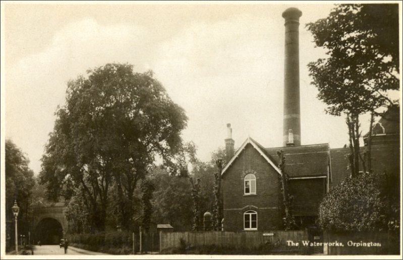
Figure
1
-
1920
The
original
waterworks
at
the
bottom
of
Tower
Road.
You
can
see
the
railway
arch
that
allows
Sevenoaks
road
to
pass
under
the
railway
embankment
to
Green
St
Green.
The
pumping
station
pumped
water
to
holding
reservoirs
at
Farnborough,
Castlewood,
Southfleet
and
Bickley.
It
was
in
operation from 1880.
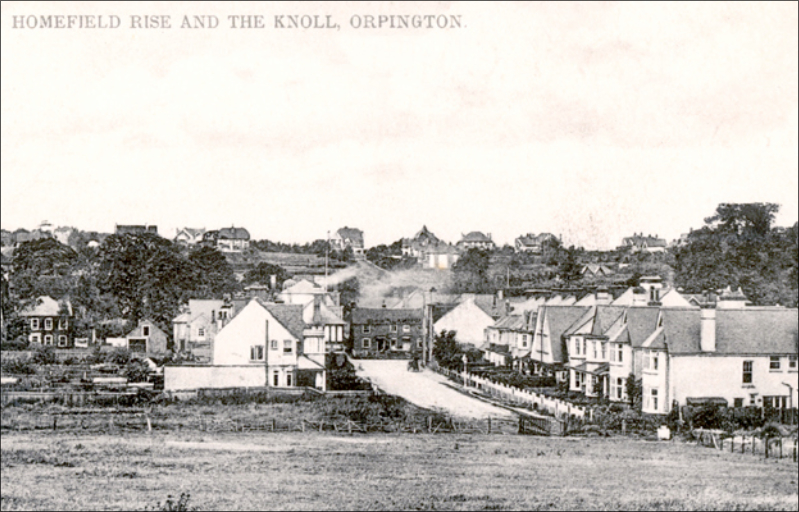
Figure
2
-
1916
A
view
from
what
is
now
Homefield
Rise
former
‘Council
Estate’.
Looking
down
you
can
see
the
High
St
running
from
left
to
right
with
‘The
Knoll’
in
the
back
ground.
Some
of
the
houses
in
Homefield
Rise
(in
this
picture)
are
still
there
today.
Figure
3
-
1890
Aynscombe
House
is
located
adjacent
to
where
the
current
Anchor
and
Hope
pub
is.
As
you
can
see
1890
and
the High St looked very rural.

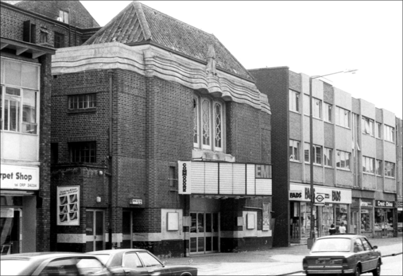
Figure
4
-
1982
The
Commodore
Cinema
was
built
in
1933.
It
was
intended
to
be
a
more
modern
alternative
to
the
Picture
Palace
at
the
other
end
of
the
High
Street.
My
parents
took
me
and
my
sister
there
a
number
of
times
and
I
remember
seeing
such
films
as
‘Clash
of
the
Titans,
Empire
Strikes
Back
and
a
number of Disney films!
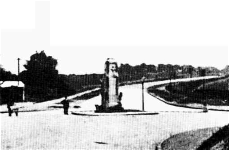
Figure
5
-
1926
Looking
from
the
War
Memorial
up
Spur
Road
before
the
houses
were
built!
To
the
right
of
the
picture
is
part
of
the
land
that
is
part
of
where
Chevening
Court
is.
Spur
road
was
part
of
a
massive
civil
engineering
project
to
build
a
road
that
would
bypass
Orpington.
and
Green
St
Green.
The
original
road
from
Sevenoaks
came
up
Badgers
Mount,
down
through
Pratt’s
Bottom
and
into
Green
St
Green
High
St..
The
bypass
took
the
road
from
Hewitts
Farm
and
down
behind
Orpington
and
then
connecting
it
back
up
to
the
main
road
where
Carlton
Parade
is.
Spur
Road
was
the
‘spur’
to
that
road.
As
with
the
railways
once
these roads had been built Orpington just couldn’t help but grow!